In a world where data drives decisions, knowing exactly what’s happening, where, and how fast has never been more important. That is where Remote Sensing and GIS (Geographic Information Systems) step in—two powerful technologies quietly shaping the future of sustainable development, especially in rural and ecologically sensitive regions.
Remote sensing is all about observing the Earth from afar—using satellites that orbit our planet and capture images of the land, water, and vegetation below. GIS, on the other hand, helps us make sense of this massive amount of spatial data by organizing it into maps, layers, and insights. When combined, these tools become a digital eye in the sky and a brain that can decode it all—helping us plan, act, and measure better than ever before.
At Raah Foundation, where I work as a Geospatial Specialist, we have embraced these technologies to bring real change to the ground. Our work spans several programs—from ecological restoration under the Regreen Nation initiative to water conservation, agriculture, agroforestry, and rural livelihoods. Each of these areas benefits immensely from the spatial intelligence that remote sensing and GIS provide.
So, what does that look like in practice?
We use a variety of satellite imagery—starting with freely available sources like Sentinel-2 for land use mapping, vegetation health, and water body detection. We apply advanced image classification methods like Random Forest algorithms (a smart way to teach computers how to categorize land based on training data) to monitor how land cover is changing over time. This helps us evaluate the impact of our interventions—whether reforestation, water conservation, or soil improvement.
But our analysis doesn’t stop at free sources. We also integrate paid and premium datasets for greater accuracy and depth. These include topographic maps and CartoDEM elevation models from ISRO, and official maps from the Survey of India, which offer high-accuracy terrain and boundary data. We are even in the process of exploring high-resolution commercial satellite data and drone-based imagery to capture hyper-local details for more effective micro-level planning and monitoring.
Using Digital Elevation Models (DEMs) like SRTM and CartoDEM, we conduct terrain analysis—understanding slopes, identifying water flow paths, delineating watersheds, and mapping natural drainage systems. This forms the backbone of our work in planning water harvesting structures like check dams, contour trenches, and gabion bunds. These terrain-based models ensure that our structures are placed not just by assumption, but with precision and purpose.
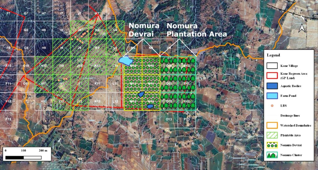
For ground-level execution, we create grid systems—dividing land into manageable square blocks that make planning, implementation, and monitoring far easier. We label and map these grids, highlight key ecological and hydrological features, and prepare village-level base maps, slope and elevation maps, and thematic layers using spectral indices like NDVI (for vegetation health) and NDWI (for water presence).
This geospatial approach is now embedded in our Regreen Nation ecological restoration efforts and our Water Support Program, where we help communities conserve and recharge groundwater. It is also critical in supporting farmers with land and resource planning under our agriculture and agroforestry initiatives.
We also work on generating reports, impact assessments, and proposals backed with solid spatial data, offering visual proof of change. For example, a before-and-after comparison of vegetation growth or changes in land cover post-intervention.
Looking ahead, we are building capacity to use drone-based monitoring, which can capture real-time, high-resolution imagery for better tracking of planted saplings, erosion patterns, and the health of conservation structures. These insights will help scale up our work with even greater precision and responsiveness.
Why does all this matter?
Because when you are working to restore degraded landscapes, support water security, and improve rural livelihoods, you need more than just good intentions. You need clarity on what exists, insight into what is changing, and evidence to know what is working. Remote Sensing and GIS give us exactly that. They are our eyes in the sky, our decision-making guide, and our accountability tool, all rolled into one.
In the coming years, as climate impacts deepen and communities seek resilience, these technologies will be essential to bridge the gap between vision and impact. At Raah Foundation, we are not just mapping one project or one location at a time—we are efficiently applying these technologies across multiple verticals and villages simultaneously, creating a unified, data-driven approach to ecological and social impact. As these technologies continue to evolve, they will become even more essential in shaping a resilient, regenerative, and well-informed rural India.